
Outside-plant fibre management for NetBox — cables, splice closures, loss budgets, and an offline-capable plant map.








Outside-plant (OSP) fibre management for NetBox. netbox-osp extends NetBox's dcim models
with a full OSP data model — cables, buffer tubes, strands, splice closures, trays, and end-to-end
fibre links — and pairs it with a full-screen interactive plant map. The plugin is offline-first
(no PostGIS, no upstream tile servers required), applies TIA-598-C colour ordering automatically,
and computes a per-link loss budget so operators can see at a glance whether a span meets its
attenuation target.
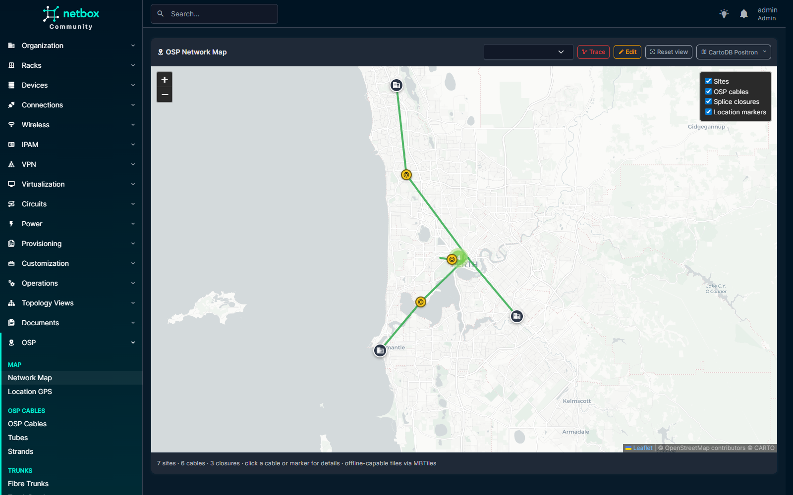
Full-screen Leaflet plant map at /plugins/osp/map/ — OSP cables, splice closures, Sites, and per-Location markers all filterable.
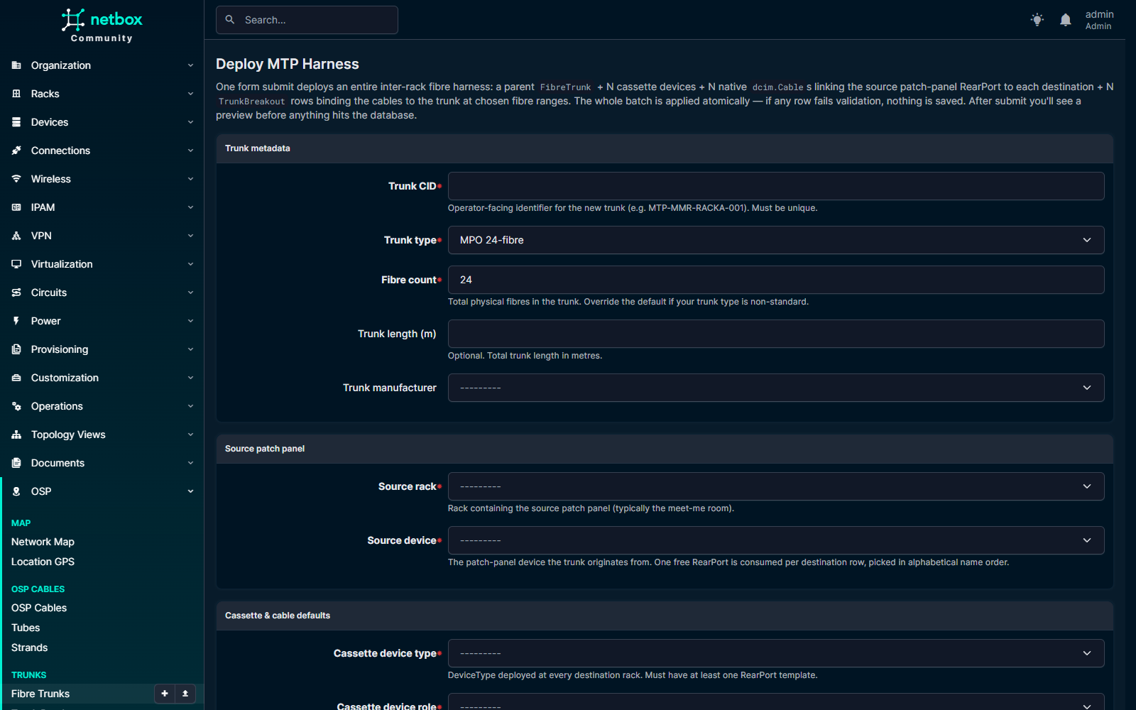
One form submit atomically deploys a parent FibreTrunk + N cassette devices + N cables + N TrunkBreakout rows.
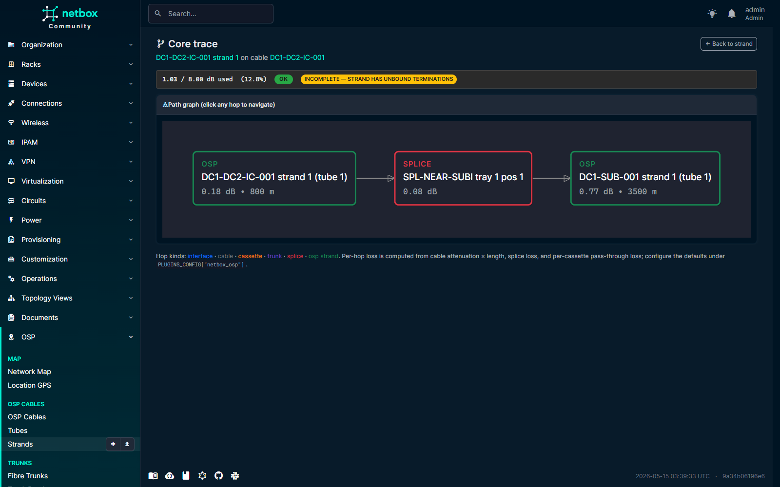
Click "Trace this core" on any Strand / FrontPort / Interface. Each hop is clickable; loss budget banded ok/warn/fail above the graph.
- OSP cable / tube / strand data model — multi-tube armoured cables with TIA-598-C
colour-coded tubes and strands. The
fibre_count == tube_count * fibres_per_tubeinvariant is enforced inclean(). - Splice closures, trays, and splices — model dome / inline / pedestal / handhole / wall-mount / aerial closures, with measured per-splice loss and OTDR trace links.
- Fibre-link loss budget — chain strands through splices into an end-to-end logical link. The plugin computes strand attenuation × length + per-splice + per-connector loss, renders an SVG gauge, and bands the result as ok / warn / fail against a configurable target budget.
- Full-screen Leaflet map with seven online base layers (OSM, HOT OSM, CartoDB Positron and Dark Matter, OpenTopoMap, CyclOSM, Esri World Imagery) plus a bundled offline MBTiles layer. The map auto-falls-back to offline after three tile errors in five seconds and remembers the operator's explicit choice across reloads.
- GeoJSON cable-route editor — leaflet-geoman drag-to-edit on cables and closures, sharing the same base-layer machinery as the main map.
- Plant-boundary validation — set a closed polygon in
PLUGINS_CONFIGandOspCable.clean()rejects any cable whose route falls outside it. Pure-Python ray-casting, no PostGIS dependency. - Per-Location GPS markers —
LocationGeois a 1:1 side-table ondcim.Locationthat adds latitude / longitude / elevation / marker colour, rendered as overlays on the network map and as a panel on the Location detail page. - REST + GraphQL APIs — full CRUD on every model under
/api/plugins/osp/...plus read-only GraphQL types viastrawberry-djangoat NetBox's shared/graphql/endpoint. - Bulk import / bulk edit for tubes, strands, splices, trays, closures, and LocationGeo — closes the ~300-click data-entry gap on a 288-strand cable.
- NetBox 4.6+ with a CI matrix covering Python 3.12 and 3.13 on Postgres 17 + Redis 7.
| netbox-osp | NetBox | Python | Postgres | Redis | Notes |
|---|---|---|---|---|---|
| 0.1.x | 4.6.x | 3.12 · 3.13 | 17 | 7 | First functional release. |
PostGIS is not required — geometry is stored as GeoJSON in JSONField columns and
plant-boundary validation uses pure-Python ray-casting. See COMPATIBILITY.md
for the full support policy, NetBox / Python / Postgres version policies, and upgrade-path
guidance.
The recommended path for production installs:
pip install netbox-ospEnable the plugin in NetBox's configuration/plugins.py:
PLUGINS = [
    "netbox_osp",
]
Apply migrations and collect static assets:
python manage.py migrate
python manage.py collectstatic --no-input
Restart NetBox and the RQ workers.
git clone https://github.com/iamjohnnymac/netbox-osp.git
cd netbox-osp
pip install -e .
Then follow the same PLUGINS / migrate / collectstatic steps above.
Add the plugin to plugin_requirements.txt:
netbox-osp
Enable it in configuration/plugins.py:
PLUGINS = [
    "netbox_osp",
]

PLUGINS_CONFIG = {
    "netbox_osp": {
        "default_attenuation_db_per_km": 0.22,
        "default_splice_loss_db": 0.10,
        "default_connector_loss_db": 0.30,
        "map_default_center": [0.0, 0.0],
        "map_default_zoom": 2,
    },
}
Rebuild and restart the netbox and netbox-worker containers.
See docs/install.md for the complete walk-through.
All settings live under PLUGINS_CONFIG["netbox_osp"]:
PLUGINS_CONFIG = {
    "netbox_osp": {
        # Fallback attenuation when an OspCable has no explicit value.
        "default_attenuation_db_per_km": 0.22,

        # Fallback per-splice loss when a Splice has no explicit loss_db.
        "default_splice_loss_db": 0.10,

        # Per-connector loss applied at both ends of every FibreLink.
        "default_connector_loss_db": 0.30,

        # Default Leaflet view as [lat, lon]. Set to your area of interest.
        "map_default_center": [0.0, 0.0],

        # Default Leaflet zoom level. 13-16 is appropriate for site scale.
        "map_default_zoom": 2,

        # Optional closed polygon of [lon, lat] vertices (GeoJSON order).
        # If set, OspCable.clean() rejects any cable whose route falls
        # outside the polygon. Pure-Python ray-casting; no PostGIS needed.
        # "plant_boundary": [
        #     [10.000, 50.000],
        #     [10.010, 50.000],
        #     [10.010, 50.010],
        #     [10.000, 50.010],
        # ],
    },
}| Key | Default | Purpose |
|---|---|---|
default_attenuation_db_per_km |
0.22 |
Fallback attenuation when an OspCable has no explicit value. |
default_splice_loss_db |
0.10 |
Fallback per-splice loss when a Splice has no explicit loss_db. |
default_connector_loss_db |
0.30 |
Per-connector loss applied at both ends of every FibreLink. |
map_default_center |
[0.0, 0.0] |
[lat, lon] for the default map view. |
map_default_zoom |
2 |
Default Leaflet zoom level (13–16 is appropriate for site scale). |
plant_boundary |
None |
Optional closed [lon, lat] polygon. Validates OspCable.route. |
See docs/configure.md for deeper docs on plant-boundary validation, per-Location GPS markers, and GraphQL.
netbox-osp composes with the wider NetBox plugin ecosystem rather than reinventing it.
Each integration below is optional — the plugin runs fine without any of them.
- netbox-attachments — attach OTDR
.sortraces, splice photos, as-built drawings, and acceptance certificates to any OSP model. Install withpip install netbox-osp[attachments]and add ascope_filterblock toPLUGINS_CONFIG. - Field QR codes — built-in QR panel on
SpliceClosureandSpliceTraydetail pages encoding the absolute URL. Field crews scan from a printed closure label and land on the splice plan with attached photos. Install withpip install netbox-osp[qrcode]; noPLUGINS_CONFIGchanges needed.
See docs/integrations.md for the full configuration snippets, use-case matrix, and verification steps.
All geometry is stored as GeoJSON in WGS84 with [lon, lat] order (RFC 7946). Conversion
to Leaflet's [lat, lon] happens at the JS boundary only.
dcim.Site                                       dcim.Manufacturer
  |  |                                                |
  |  +--< OspCable >-----------< Tube >-----< Strand --+
  |          (route GeoJSON)         |          |
  |                                  +--------- |
  |                                             +--> dcim.Cable
  |                                             |    (Strand.cable_link, optional)
  |                                             |
  +--< SpliceClosure >--< SpliceTray >--< Splice >--+
            (Point)                       (strand_a, strand_b)

  FibreLink >--< FibreLinkStrand >--< Strand
        (loss budget, status)         (ordered hops)
| Model | Purpose |
|---|---|
OspCable |
A physical fibre cable run between two sites. Stores type, attenuation, GeoJSON route, and length. |
Tube |
A buffer tube inside an OspCable. Unique on (cable, number). |
Strand |
A single fibre strand. Optional bridge to dcim.Cable via Strand.cable_link for legacy strand-as-cable flows. |
SpliceClosure |
A physical splice enclosure (dome, pedestal, etc.) sited at a location with optional GeoJSON point. |
SpliceTray |
A tray inside a closure. Holds individual splices. |
Splice |
A fusion or mechanical splice joining two strands. Stores measured loss_db and an optional OTDR trace URL. |
FibreLink |
A logical end-to-end link composed of one or more strands joined by splices, with a configurable loss budget. |
FibreLinkStrand |
Through-table assigning strands to a FibreLink in ordered hops. |
LocationGeo |
1:1 side-table on dcim.Location adding latitude / longitude / elevation / marker colour for per-Location pins. |
See docs/data-model.md for the field-by-field reference.
All endpoints sit under /api/plugins/osp/. Standard NetBox auth (Authorization: Token <key>)
and filtering / pagination apply.
| Path | Methods | Notes |
|---|---|---|
/api/plugins/osp/cables/ |
GET / POST / PATCH / DELETE | List + CRUD OspCable |
/api/plugins/osp/tubes/ |
GET / POST / PATCH / DELETE | List + CRUD Tube |
/api/plugins/osp/strands/ |
GET / POST / PATCH / DELETE | List + CRUD Strand |
/api/plugins/osp/closures/ |
GET / POST / PATCH / DELETE | List + CRUD SpliceClosure |
/api/plugins/osp/trays/ |
GET / POST / PATCH / DELETE | List + CRUD SpliceTray |
/api/plugins/osp/splices/ |
GET / POST / PATCH / DELETE | List + CRUD Splice |
/api/plugins/osp/links/ |
GET / POST / PATCH / DELETE | List + CRUD FibreLink |
/api/plugins/osp/location-geos/ |
GET / POST / PATCH / DELETE | List + CRUD LocationGeo |
Types are registered with NetBox's shared /graphql/ endpoint and authenticate with the same
API token as REST.
{
  osp_cable_list {
    id
    cid
    status
    fibre_count
    length_m
  }
}
The schema is read-only — use REST for writes.
| Path | Purpose |
|---|---|
/plugins/osp/map/ |
Full-screen network map (HTML) |
/plugins/osp/map/data/ |
Map GeoJSON FeatureCollection (filterable) |
/plugins/osp/tiles/<z>/<x>/<y>.<ext> |
Tile proxy backed by MBTiles |
The plant map uses Leaflet with seven public online base layers plus a bundled offline MBTiles
layer, and auto-falls-back to offline after three tile-load failures in five seconds. To replace
the bundled stub with your own area's imagery, drop one or more .mbtiles files under
<MEDIA_ROOT>/osp_tiles/ — they take precedence over the bundled basemap. See
docs/tile-bundling.md for the tilemaker-based build workflow.
git clone https://github.com/iamjohnnymac/netbox-osp.git
cd netbox-osp
pip install -e ".[test,docs]"
pre-commit install
Run the lint + format check and the test suite:
pre-commit run --all-files
python -m coverage run -m pytest
Ruff (lint + format) is configured in pyproject.toml to match the wider NetBox plugin
ecosystem; the pre-commit hook runs it on every commit.
- Short-term — extend the permission-matrix tests to the remaining seven primary-object view
sets, finish debugging the GraphQL
osp_<model>_listfield surfacing against a live/graphql/endpoint. - Medium-term — OTDR trace upload, DWDM channel allocation on
FibreLink, QGIS-friendly export of cable routes. - Long-term — optional PostGIS backend for users who want native spatial indexes, and submission to the NetBox Labs Plugin Certification Program.
Issue tracker for the live picture: https://github.com/iamjohnnymac/netbox-osp/issues.
PRs welcome. Please run pre-commit run --all-files and ensure the test suite passes before
pushing, and keep new code aligned with the ruff config in pyproject.toml. Substantive
changes should add or update tests under netbox_osp/tests/. A formal CONTRIBUTING.md will
land alongside the first cert-program submission.
- Bug reports — https://github.com/iamjohnnymac/netbox-osp/issues
- Questions and discussion — https://github.com/iamjohnnymac/netbox-osp/discussions
- Chat —
#netbox-pluginson NetDev Slack
Apache-2.0. See LICENSE for the full text. Icon CC BY 4.0.